| Author | Message | ||
Brian Vogel Grand Master Username: guyslp Post Number: 3132 Registered: 06-2009 |
I'm just seeing the news about the extreme flooding in New South Wales. Having lived through flooding before myself, you have my deepest sympathy, as the worst of it is the cleanup and rebuilding afterward. I hope that all are safe now and that anyone who has been impacted by the flooding will have the intestinal fortitude and mutual support of their respective communities so that everyone can get through this in the best way possible. Brian | ||
David Gore Moderator Username: david_gore Post Number: 3899 Registered: 04-2003 |
My partner and I share her home in the heavily flood-affected Manning River Valley on the Mid-North Coast of NSW and, fortunately, her home is situated on a ridge leading down to the flood plain of the river close to the river mouth to the ocean and is well above the flood level. However, the local Council allowed a developer to create housing blocks on the flood plain below subject to the developer backfilling the blocks to a specified height above the designated maximum flood level for the river which the developer undertook. The current flood level is the highest ever experienced and the flooding has coincided with some high tides - one of our neighbours has advised some of these blocks have been subjected to floodwater at high tide. It will be interesting to see what consequences eventuate. We are at our Sydney home at present and are not in a flood-prone area but look down to the flooded Georges River. | ||
Jeff Martin Frequent User Username: jeff_r_1 Post Number: 213 Registered: 07-2018 |
One extreme to too another ! Not enough water, now too much. | ||
ross kowalski Prolific User Username: cdfpw Post Number: 1533 Registered: 11-2015 |
David, Stay Safe. | ||
Trevor Hodgekinson Frequent User Username: wm20 Post Number: 230 Registered: 11-2006 |
You can thank-you Mr ................. ( name not posted because foreign controlled developers have very deep pockets for deformation littigation ). Back in the 60's a then mostly OZ owned developer challenged the 100 year flood level ban on house construction . as they had options on vast tracts of farm land in the Georges river flood plane they took it to the high court & won the case ( judges have shares & property portfolios too ). Then in the 70's another group of parrasites challenged the 75 year lock out using the same arguement and they were also successful. Thus for the next 30 or so years land that is on a 50 year or longer flood plane was open for speculation and there is nothing a local council or state government could do about it aside from challenging the original high court ruling. Fortunately the ruling did get repealed but it still meant that hundreds of millions of taxpayers money was spent on the Bankstown Lakes Flood Mittigation system . The local council down here requires all new property contracts to have a flood clause in them mandating the moving of any residences to a level above the known highest level of the Nepean river, one of the few intelligent , common sense things they have done. Back when water had to be carted to the house by hand and rivers were the major transport routes then building along river banks was acceptable and we even developed a housing style to compensate for floods, it is called the Queenslander . However now days with roads & pumps there is no excuse for any dwelling to be below the 100 year flood level. AFAIK not a single river has risen above the highest known flood level. The media skirt this by using terms like "highest since 19XX" rather than how they should be described as " YY meters below the highest know flood level " but that does not sound any where near as dramatic and might adversely affect property values. Our old neighbour moved to Macksville to be with her daughter & grandchildren on their bannana farm. The house flooded out twice in the 80's so they built a new one + machinery & packing sheds on the highest point with a 15" high garage underneath to lift the floor level above the flood level . They then did a deal with the neighbour & put a gate into his property so they had a flood evacuation route. Since then the house has had minor flooding above the floor level only once & they built it to take this without damage . | ||
David Gore Moderator Username: david_gore Post Number: 3903 Registered: 04-2003 |
Trevor, Our neighbour at Old Bar worked as the Project Manager for a well-known property developer in Sydney in the 1950-1980 era and knows where all the secrets are buried! I have read reports that the recent flood levels for the Gloucester and Manning Rivers exceeded the highest levels recorded in the past but I cannot cofirm this is the case. | ||
David Gore Moderator Username: david_gore Post Number: 3904 Registered: 04-2003 |
Further to the above comment, I have been able to download the flood period river heights from the official Bureau of Meteorology automatic river height gauge on the Gloucester River which feeds into the Manning River system. This gauge is located on her family property near Bundook and is close to this river's connection with the Manning River proper. The river height under normal conditions is 2 to 3 metres which corresponds to a considerable flow of water. The recorded peak of 14 metres represents a huge flow of water in the river and contributed a significant volume of water to the subsequent flooding near Taree. 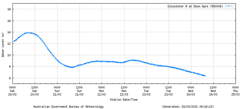 . | ||
Trevor Hodgekinson Frequent User Username: wm20 Post Number: 231 Registered: 11-2006 |
Yes one of the problems we have down here is calling DRAINS rivers. Most OZ rivers are just oversized storm water drains so in very heavy rain they fill very quick & flow very fast. The problem we have here is governments do not listen nor believe any scientific evidence. Most geologist can look at the sides of a river valley & tell you what was the very highest ever water level and in many cases roughly when it was and this should form the basis of any usage decisions. Flood plains are for agriculture, not property development. I find it very disappointing that we can move a river & a rail line if it is the way of an airport. We can shift entire towns , roads & rail lines if some foreign company wants to dig up some minerals. But we can't shift towns & villages to higher ground in order to save the lives of the inhabitants & those who are expected to rescue them. Decades ago I remember listening to a public lecture by an ecologist who said that we should set aside around 1 mile either side of any regular watercourse as a National Park as that is where most native animals feed & reproduce, rather than just encircling a big lump of land & calling it a National Park. And the river parks should go all the way to their ocean outfall so fish & aquatic life forms can access the fresh, brackish & salt waters unhindered. The other side effect of this would be putting most people above flood lines and infrastructure high above flood damage heights. ` |